Road Test: Palm Springs to Quartzsite, AZ - Let's Visit Hi Jolly
Let's go for a long drive, and visit an unheard of Historic site
After the drive to Las Vegas produced less than stellar results, I was kind of confused. What's the true range on the car on the highway? I felt the only way to find this out would be to do just that, head out on the highway. I didn't want to drive to LA because of the traffic I thought that would skew the results. I didn't want to drive to Vegas because it's too far, and honestly, what's the point of driving to Barstow?
So my only other option, is to head east young man! Let's drive to Arizona. I want this to be a single charge run. I want to minimize the time, and also minimize
the cost. If I can charge at home and make it back home, that would reduce my charge cost down to $10-$12 in costs. So looking at the map, I wanted to plan a
spot that would be 120 to 140 miles out, and that spot turned out to be Quartzsite, Arizona.
I also thought would give me a real world result that's about as close to EPA test estimations as I can get, as Quartzsite sits at about 300 feet above sea
level, and Palm Springs sits around 400 feet above sea level, so this should be a nice, flat drive mimicking results the engineers at EPA get in their lab.
I head out on a beautiful, clear Sunday afternoon, a perfect 75 degrees in Palm Springs. Traffic is light on the 10 freeway at this point and as I head out of the Coachella Valley, it's easy cruising as I set the cruise control to 75 miles an hour. Now I'm getting passed by cars that obviously don't have cruise control set. One minute they're doing 85, the next minute they're doing 65. I stick to the slow lane, but unfortunately I don't get a good draft off of anyone But oh well, it is what it is and that's the whole point. This is real world driving so we'll just see what happens.
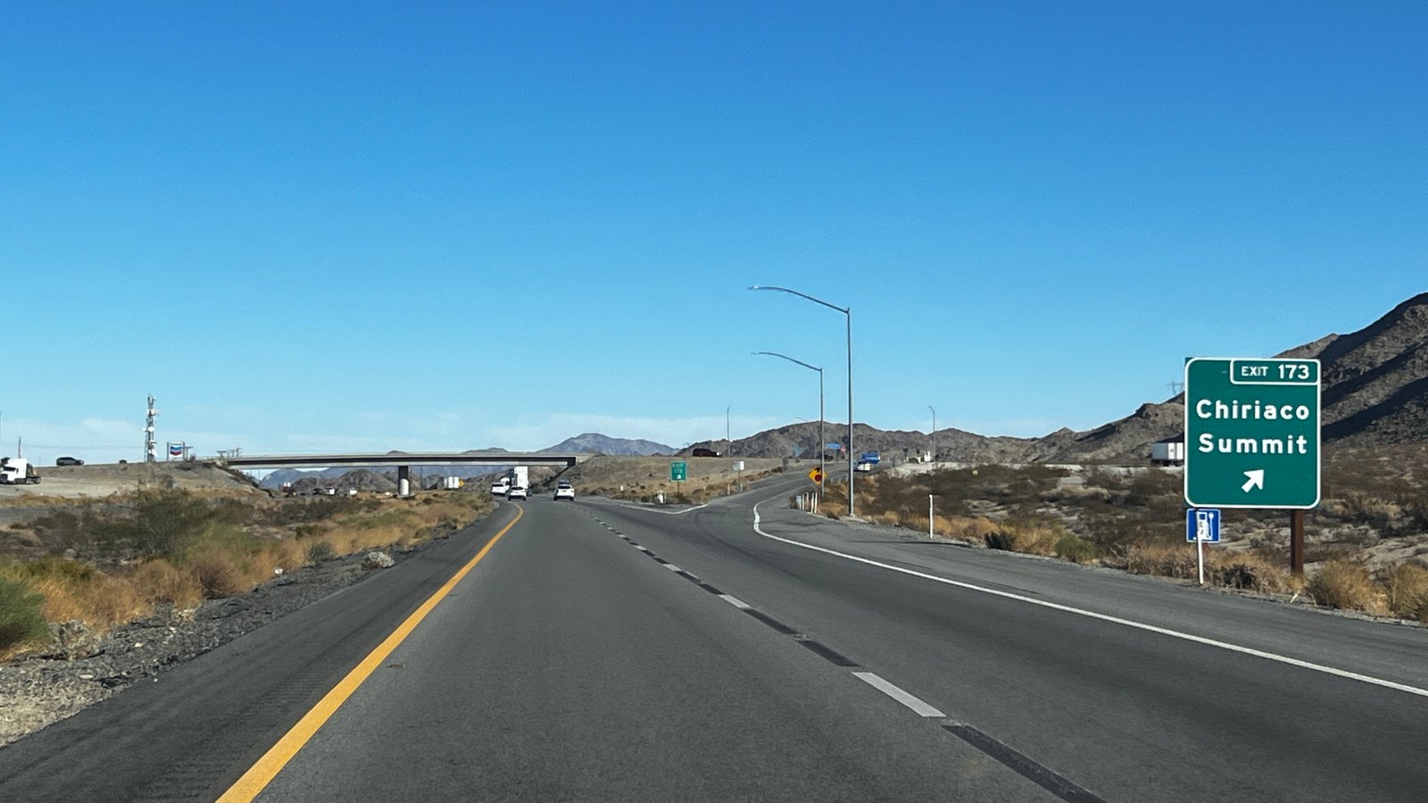
I'm driving along and I noticed that I'm going quite a bit uphill. I see mountains on the either side of the road and it's actually quite a pretty view. And then I noticed a sign that causes some concern: Chiriaco Summit. Summit? What summit? There should be no stinking summit out here! This is Desert, oh wow, I didn't realize that even though Palm Springs and Quartzsite sit pretty much at the same level, there is quite a little mountain range in between the two. Chiriaco Summit sits at 1400 feet above sea level, really not much of an elevation, I mean Vegas sits at 2000, but it did catch me by surprise. And again, oh well that's life. This is the real world and sometimes, you just have a summit.
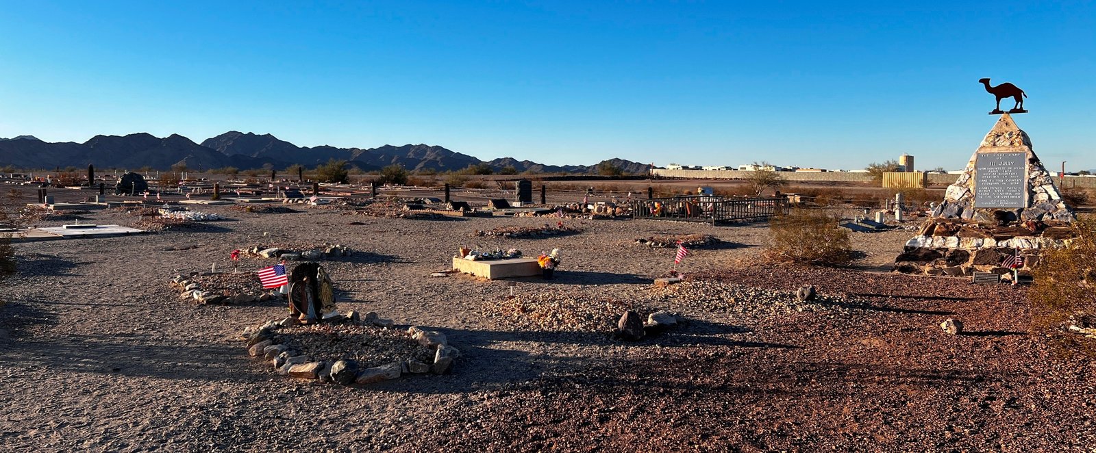
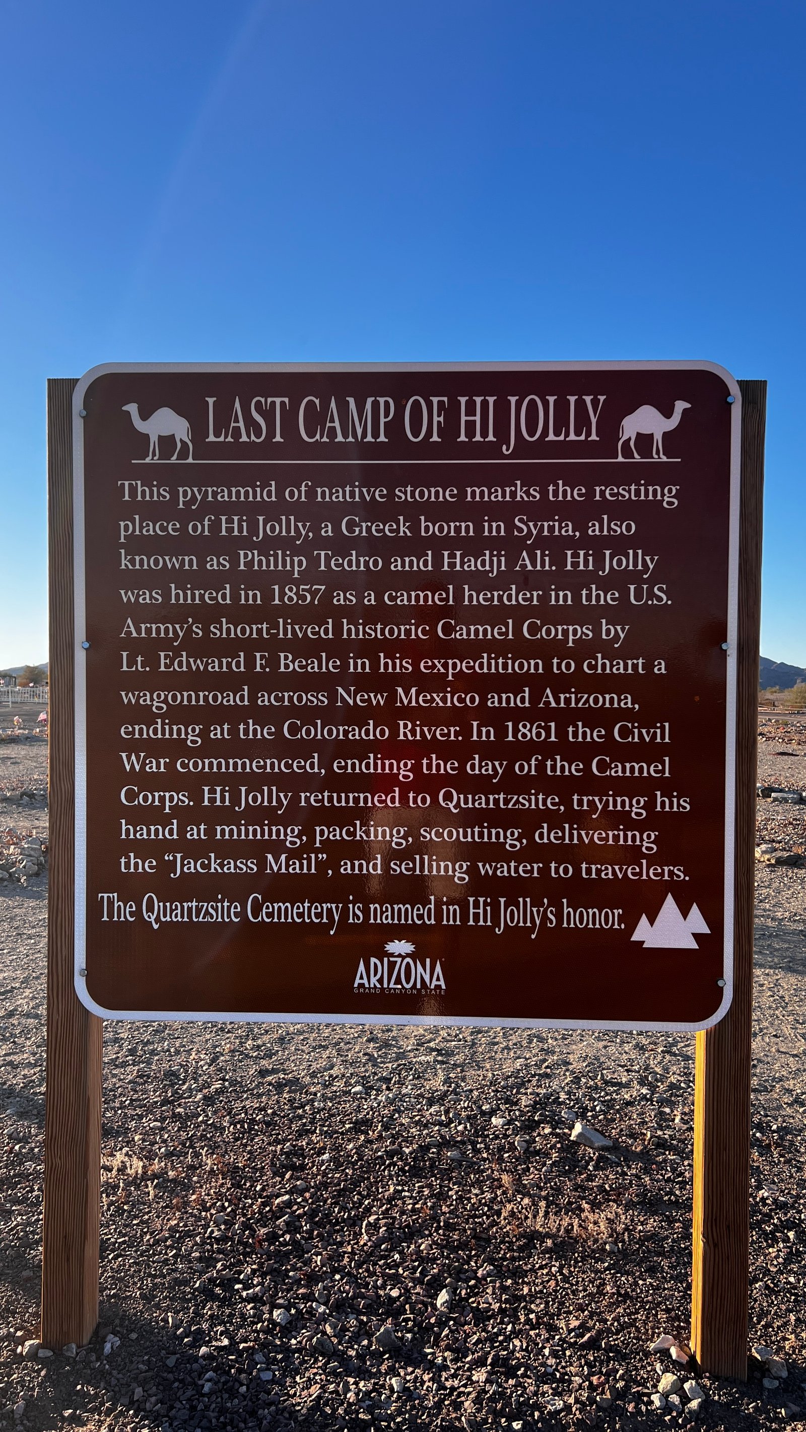
I reach Quartzsite and head to my tourist stop, the Hi Jolly Tomb. This is a memorial gravesite dedicated to Hadji Ali, a Syrian-born Greek hired by the U.S. Army in 1857 as a camel herder in the Army's Camel Corp program. The purpose was to use the Dromedary Camel, known for their water humps that allow traveling the desert at great distances, to map a wagonroad across the New Mexico and Arizona deserts. The road was to end at the Colorado River, but unfortunately, as the Civil War broke out, the program was ended in 1861, and Hadji Ali, "Hi Jolly", returned to Quartzsite for the mining and to deliver mail.
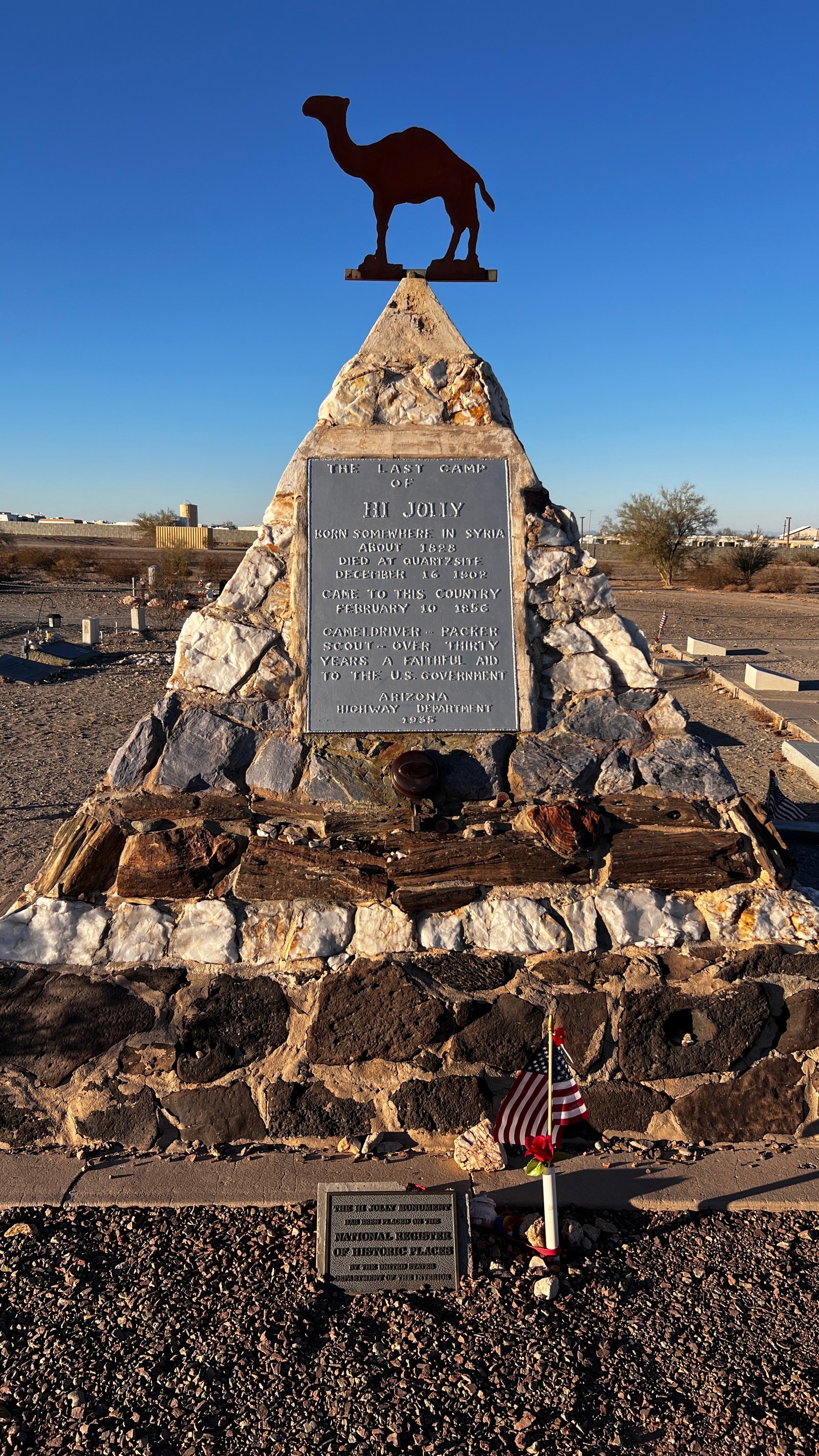
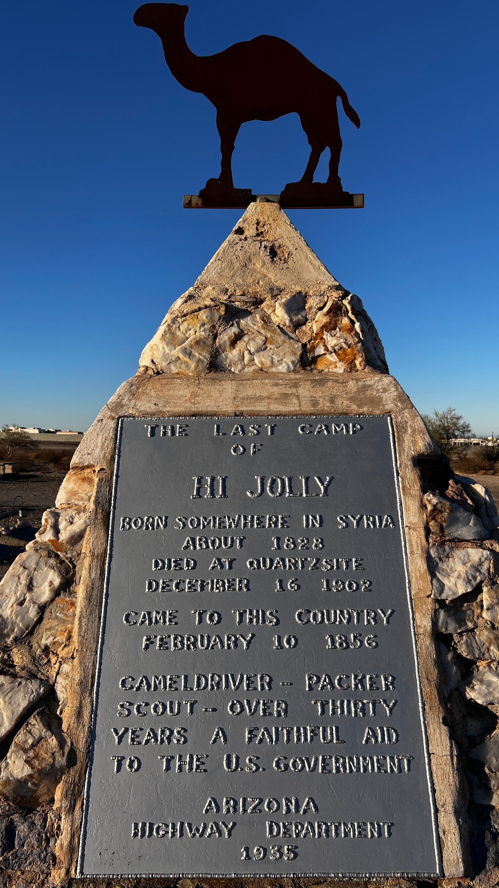

“Old-timers out in Arizona Tell you that it’s true You can see Hi Jolly’s ghost a-travelin’ still When the desert moon is bright He comes ridin’ through the night Leadin’ four and twenty camels ‘cross the hill. ”
“Hi Jolly, the Camel Driver,”by Randy Sparks, recorded by the New Christy Minstrels, 1962 ©Cherrybell Music Company

The Quartzsite cemetery is quite interesting for the fact that other than the Hi Jolly Tomb, it's quite small, very flat, and filled with graves of people from the 1800's. So the question is: Who's been keeping these graves intact and not letting them succumb to the Arizona desert? And why does this cat keep following me? Inquiring minds want to know. But I don't so it's time to head back because it's getting keep of creepy here.
Of course, as I start back, the Fisker starts pinging and bonging error messages on the dash, so I pull over. I get out of the car and click the remote to lock it. Sometimes, leaving the Fisker in stand still mode, where I exit but don't lock the car, results in multiple system warnings. So I lock the car and look over the hood and notice some Tesla superchargers. Then I notice more...and more! Holy cow, this tiny little rest stop of a town has about 40 superchargers, maybe more. I drive around the lot and think how interesting that this is built with so many chargers. These chargers are the modern day water stops for the weary Tesla drivers making these cross-state line trips. The same way Hi Jolly served water to weary travelers crossing the southern desert..
The drive home is just as uneventful, although it does give me a chance to record some fun happenings in the car: The rear reader light that comes on and goes off as if a haunting is happening, the yellow blind lane indicators, and the regen indicators. All in all, its been a beautiful drive. Lovely desert scenery, a wonderful sunset, and a visit to Hadji Ali's final resting place.
Trip Results:
- Calculated Range at Start: 286 miles
- Total Miles Driven: 273 miles
- Remaining Miles: 22 miles
- Real World Range: 295 miles